


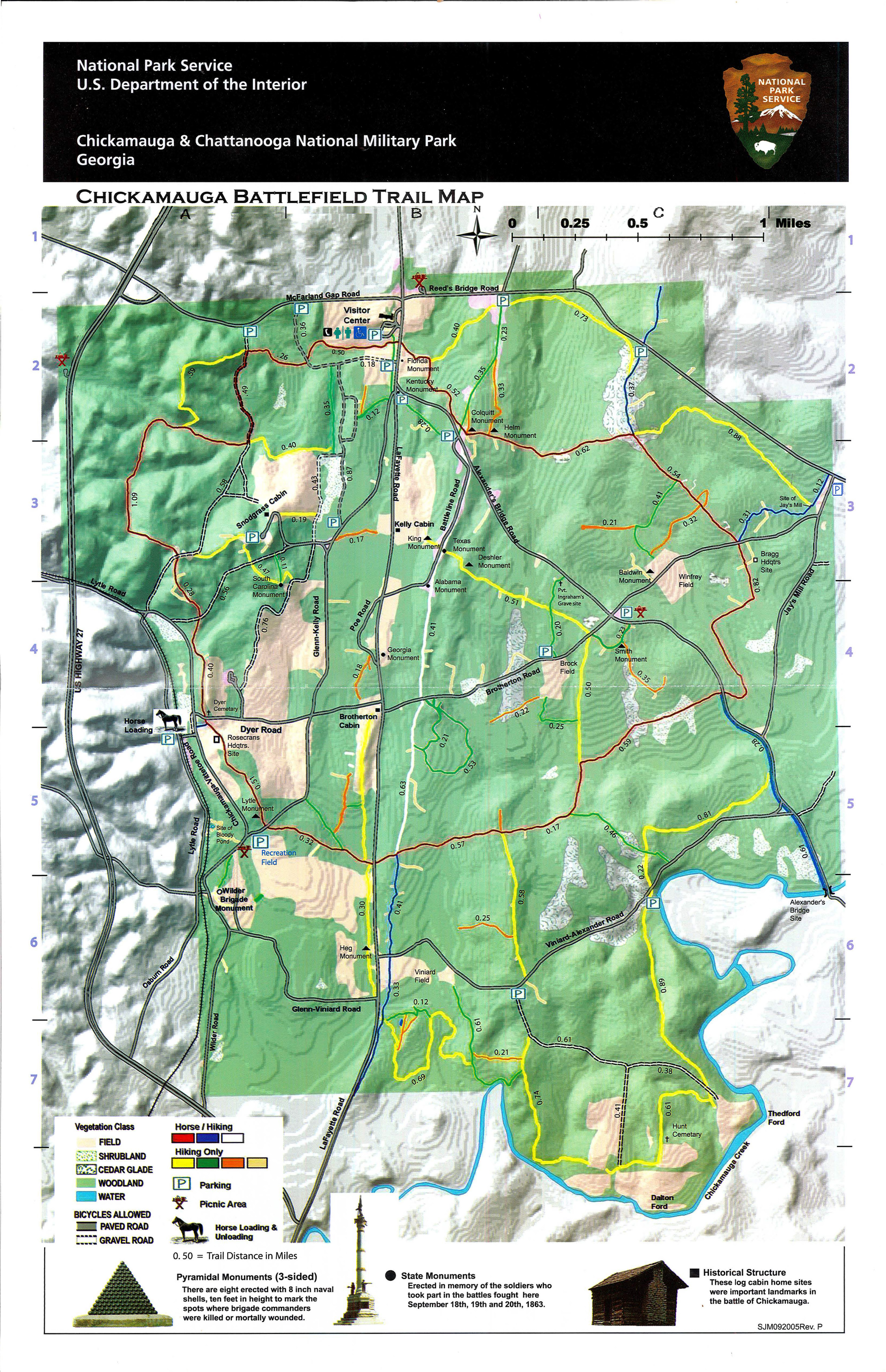
Chickamauga Battlefield
Where it All Began
The Battle of Chickamauga took place over three days in September of 1863, marking the start of the Civil War Campaign for Chattanooga. Some 26 years later, veterans from the North and the South met nearby at Crawfish Springs for the Blue and Gray BBQ, an act of reconciliation and healing that sparked the preservation of nearly 5,000 acres and the first nationally protected Civil War Battlefield at Chickamauga.
More than 1,500 commemorative features and 50 miles of trails cross this vast historic landscape, welcoming visitors of all ages to experience the natural and historic resources forever protected here.
A Visitor Center is located at north end of the Park (click HERE for more information + directions) and recreation opportunities include walking, running, hiking, biking, and horseback riding (click HERE for a trail map).

Lookout Mountain Battlefield
Above the Clouds
On November 24, 1863, Union troops under the command of General Joseph Hooker swept the northern slopes of Lookout Mountain in what became known as the "Battle Above the Clouds." Around 3,000 acres are preserved within Lookout Mountain Battlefield.
A Visitor Center is located at Point Park (click HERE for more information + directions).
Point Park is the only location with an entrance fee - click HERE for details on entrance fees.
More than 30 miles of trails are available for hiking and trail running. Rock climbing is also available at Sunset Rock (limited trailhead parking area - NO restrooms). A larger trailhead parking area can be found at Cravens House though the building is closed to the public (NO restrooms).

Missionary Ridge
“The Death Knell of the Confederacy”
On November 25, 1863, more than 50,000 Union soldiers stormed the Confederate defenses along Missionary Ridge, from Rossville Gap at the Georgia border all the way up to Tunnel Hill at the northern end of Missionary Ridge. By the end of the day, Chattanooga was firmly in Union hands. It was, as one Confederate officer later described it, "The death knell of the Confederacy."
Along the crest of Missionary Ridge are a series of eight reservations and monuments that preserve and tell the story of key areas of the Battle of Missionary Ridge. Take a scenic drive and amaze your friends and family with the sight of cannons scattered in the front yards of homes, then pull into one of the reservations offering breathtaking views of the Chattanooga valley.

Moccasin Bend National Archeological District
Forever Moccasin Bend
Moccasin Bend is one of the most unique units found in the entire National Park Service system, spanning 12,000 years of continuous human habitation. The site also played a significant role during the Civil War in the Campaign for Chattanooga.
The "Gateway Site" is a grassy meadow offering beautiful views of Lookout Mountain and the Tennessee River. An interpretive display along Hamm Road will help orient you when you arrive, and the National Park Service and National Park Partners are in the midst of a project to “Open the Gateway” with a new visitor entrance coming soon!.
Additionally, there are two interpreted trails on Moccasin Bend - The Brown's Ferry/Old Federal Road Trace and the Blue Blazes Trail. The former is a quick walk to the River along a Trail of Tears route that later became the US Army supply line (or “cracker” line) during the Civil War Campaign for Chattanooga; the latter is a loop trail that traverses the Bend near where Woodland era Indian villages once stood.

Orchard Knob
Respect the Knob
Orchard Knob Reservation was preserved for its historic significance as the forward observation post for General Ulysses S. Grant as he watched the US Army assault on Missionary Ridge.
Conveniently located just a few minutes from downtown Chattanooga, Orchard Knob is a great spot for a quick hike at lunchtime or a more leisurely stroll to the top to take in the 360 degree views and the stunning sunsets.
Preserving the battlefield created an oasis for wildflower populations in the midst of a bustling city. Check out our blog post about an active partnership that fostering a sense of stewardship and appreciation for Orchard Knob’s abundant native plant life.

Signal Point
Hold the High Ground
Union soldiers used Signal Point to communicate with the outside world by creating a complex signaling system on portions of high ground along the Tennessee River. Signal Point was the key station receiving and sending messages from the besieged city of Chattanooga to Bridgeport, Alabama, thence by telegraph to the North.
Today, Signal Point is a popular hiking destination. In addition to scenic views of the Tennessee River, Signal Point Reservation is an access point for the Cumberland Trail, which stretches several hundred miles across the Cumberland Plateau.
The Signal Point Reservation is located on Signal Mountain, Tennessee at the end of Signal Point Road. There is parking available, and restrooms are open seasonally in the spring, summer, and fall.